
Where Does My Land End? How to Find Property Lines Without Paying a Surveyor
Written by
Manny Pantiga
You want to build a fence. Or maybe you want to widen your driveway. Or perhaps you are just 99% sure your neighbor’s new rose bush is technically planting its roots in your dirt.
So, you walk outside. You look at the grass. And you realize you have no idea where your property actually ends.
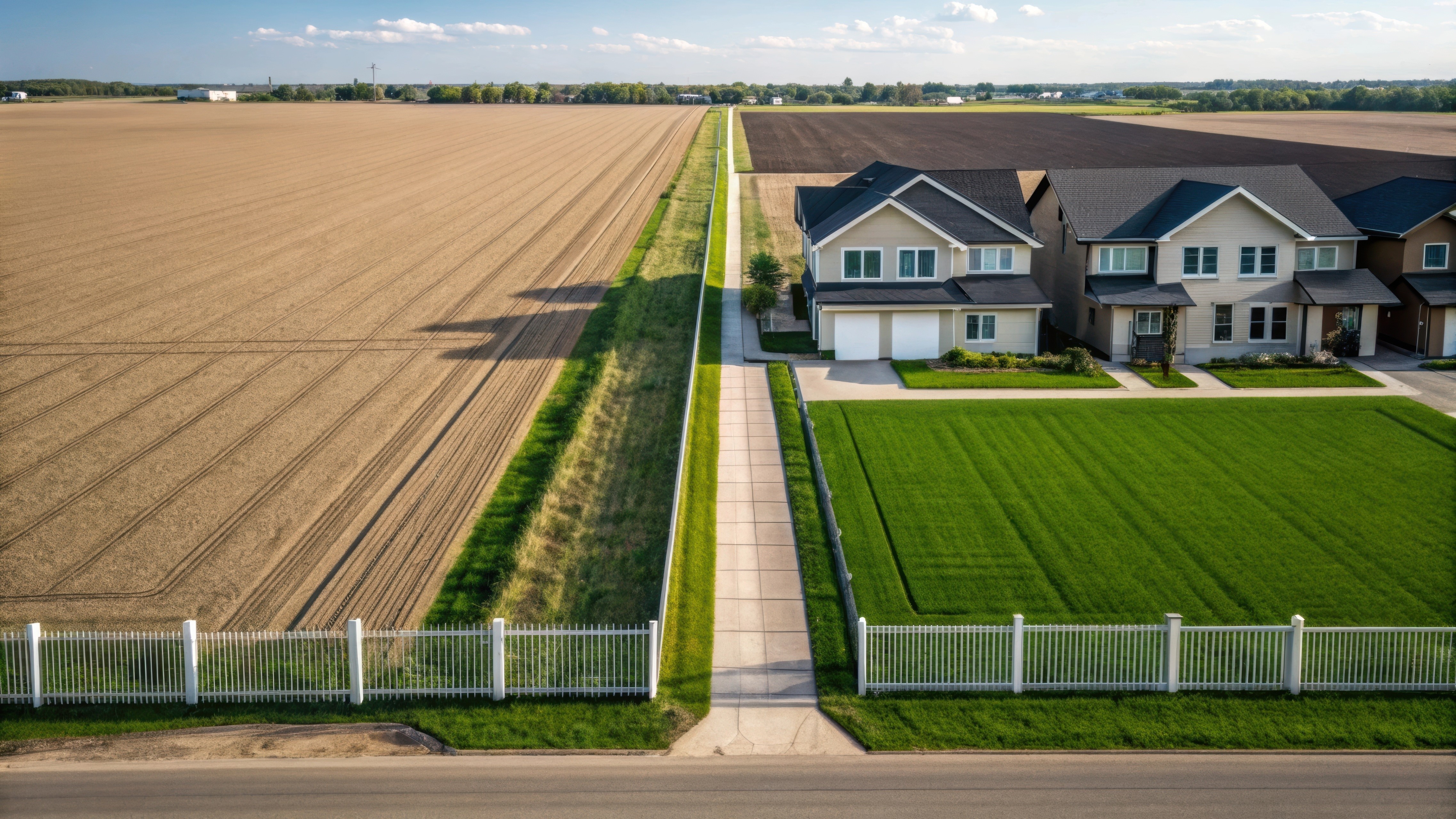
Most homeowners assume the utility pole is the corner. (It usually isn't).
Others assume the sidewalk edge is the line. (It definitely isn't).
If you guess wrong, it gets expensive fast.
According to HomeAdvisor’s 2025 Cost Guide, the average cost of a professional land survey now hovers between $376 and $769, with complex lots often costing upwards of $1,000.
But before you spend that money, you should know that the clues are already there. You just need to know how to read them.
Here is how to find property lines for free (or cheap) using the "Digital," "Physical," and "Legal" methods.
Method 1: The "Digital" Hunt (County GIS Maps)
Stop looking at Google Maps.
Google Maps is great for finding a coffee shop, but it is terrible for property lines. The satellite overlay is often shifted by 5 to 10 feet. If you build a fence based on Google, you might be building it on public land.
You need the official source: The GIS Map.
GIS stands for Geographic Information System. Almost every county in the U.S. has digitized their plot maps into a free, interactive database.
How to do it:
Go to Google and search: [Your County Name] GIS Map or [Your County] Parcel Viewer.
Enter your address.
Turn on the "Lot Lines" or "Parcel Dimensions" layer.
What you will see:
Unlike a standard map, this will give you the exact dimensions. It won’t just show a square; it will say "105.5 feet along the North boundary."
Pro Tip:
Look for "monuments" on the map. Does the line end exactly perpendicular to a fire hydrant? Does it line up with a neighbor’s driveway cut? Use these permanent physical objects to estimate where the line falls on the ground.
Method 2: The "Physical" Hunt (The Metal Detector Trick)
This is the most reliable DIY method, and frankly, it makes you feel like a treasure hunter.
When your house was first built (or the land was subdivided), a surveyor likely drove iron pins (rebar) into the ground at the four corners of the lot.
Over time, grass grew over them. Dirt covered them. But they are still there, usually buried 6 to 10 inches underground.
How to find them:
Rent or borrow a metal detector. You don't need a high-end one; a cheap $40 model from a hardware store works fine.
Start at the sidewalk. Walk to where you think the corner is (use your GIS map dimensions to get close).
Listen for the beep.
Dig (carefully).
What you are looking for:
You are looking for a rusty iron rod, often topped with a colored plastic cap (yellow or pink) that has the surveyor’s license number stamped on it.
If you find this pin, do not move it. That is a federal offense. But congratulations—you just found the exact legal corner of your property for free.

Method 3: The "Paper" Hunt (The Plat Map)
If you can't find the pins and the GIS map is confusing, you need to go back to the paper trail.
In our previous guide on How Old Is My House?, we talked about visiting the County Recorder’s office to find deeds. That same office holds the Plat Maps.
A Plat Map is a drawing of your entire neighborhood as it was originally designed.
Why this is better than a deed:
Your deed is just text. It says "Starting from a point..." which reads like stereo instructions.
The Plat Map is a drawing. It shows how your lot fits into the puzzle of the entire block. It will show you easements (utility strips where you cannot build) and "setbacks" (how far back from the road your house must be).
The Danger Zone: Encroachment and "Adverse Possession"
Why does all this matter? Can't you just guess?
No.
If you build a fence 6 inches over the line, your neighbor can legally force you to tear it down.
But there is a scarier concept called Adverse Possession (sometimes called "Squatter’s Rights").
According to FindLaw’s State-by-State Guide, if a neighbor uses a piece of your land openly and without permission for a certain number of years (ranging from 5 years in California to 20 years in many other states), they can legally claim ownership of it.
Example:
Your neighbor builds a shed that crosses 2 feet onto your property. You are nice and don't say anything.
Fifteen years later, you try to sell your house.
A surveyor comes out and says, "Actually, you lost that 2 feet of land a decade ago."
Suddenly, your lot is smaller, and your property value drops.
This happens more often than you think. It’s similar to the issues we discussed in our guide on Selling a House with Unpermitted Work—legal grey areas can freeze a sale instantly.
When to Call the Pro
If you are just planting a garden, the DIY methods above are perfect.
But you should pay the $500+ for a surveyor if:
You are building a permanent structure (fence, garage, addition).
You are in a feud with a neighbor.
You are selling and the buyer demands it.
A professional survey is basically an insurance policy against a lawsuit.
The Bottom Line: Land is Money
We spend so much time worrying about the square footage inside the house that we forget about the square footage outside.
But in 2025, land value is rising faster than structure value in many metro areas. Knowing exactly where your land ends isn't just about fences; it's about protecting your equity.
Does your lot size match what the tax man thinks?
If you find out your lot is actually bigger (or smaller) than recorded, it changes your value. Check your home’s real-time estimate based on your actual property details.
See Your Home's True Value Here

Share post
" height="48px" id="wCNVpPYFW" width="48px"/></g></svg>)
" height="47.9906px" id="ug1HcU5E4" width="47.9719px"/><path d="M 12.328 0 C 5.522 0 0 5.522 0 12.328 C 0 19.134 5.522 24.656 12.328 24.656 C 19.134 24.656 24.656 19.134 24.656 12.328 C 24.656 5.522 19.134 0 12.328 0 Z M 12.328 20.325 C 7.913 20.325 4.331 16.744 4.331 12.328 C 4.331 7.913 7.913 4.331 12.328 4.331 C 16.744 4.331 20.325 7.913 20.325 12.328 C 20.325 16.744 16.744 20.325 12.328 20.325 Z" fill="rgb(0, 0, 0)" height="24.6562px" id="X8jeE9Dvb" transform="translate(11.672 11.672)" width="24.6562px"/><path d="M 5.756 2.878 C 5.756 4.472 4.462 5.756 2.878 5.756 C 1.284 5.756 0 4.463 0 2.878 C 0 1.284 1.294 0 2.878 0 C 4.462 0 5.756 1.294 5.756 2.878 Z" fill="rgb(0, 0, 0)" height="5.75623px" id="oW9UZS7DI" transform="translate(33.938 8.306)" width="5.7562px"/></g></svg>)
" height="33.81818px" id="o4k1AL35c" transform="translate(0.048 7.091)" width="48.0000484px"/></g></svg>)